Where you are depends on where you measure from
Issue 91 : Jul/Aug 2013
A chart datum is a reference from which data or information displayed on a nautical chart is measured. One type of chart datum, the vertical datum, is the reference used for the charted water depth. A common water-depth reference datum is mean lower low water, abbreviated MLLW. There are other types of chart datum. One of these is the horizontal datum that establishes where the latitude and longitude grid is placed on the chart.
Our non-spherical Earth
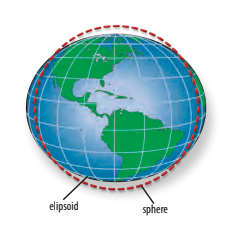
In 300 B.C. the Greeks established that the Earth was a sphere. But the Earth is not a true sphere. Due to its rotation, it bulges out at the equator and is flattened at the poles, so its shape is closer to an ellipsoid.
Ellipsoids come in an infinite variety of mathematical shapes. The Clarke Ellipsoid, promulgated in 1866, was the first ellipsoid to represent the Earth. By the 20th century, it was clear the Clarke Ellipsoid was not accurate and cartographers developed the North American Datum Ellipsoid of 1927, or the NAD 27 ellipsoid.
This ellipsoid was fairly accurate for North America but not for the rest of the world, so in 1966, the World Geodetic System developed a new mathematical model called the World Geodetic System Ellipsoid of 1966, or WGS 66. The mathematical models continued to be refined and WGS 72 was adopted next. Finally, a new North American ellipsoid was also proposed, the NAD 83. A year later, the WGS 84 model was adopted. The NAD 83 and the WGS 84 are, for all practical purposes, identical.
The geoid
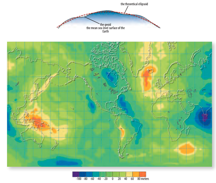
It looked as though the problem of a non-spherical Earth was finally solved. However, because differences in gravity at various points on the Earth’s surface create depressions and bulges, the surface is not a smooth mathematical ellipsoid. The actual shape of the Earth is now referred to as the geoid. It very closely approximates the mean sea-level surface of the Earth, and shows differences up to plus and minus about 100 meters (328 feet) from the theoretical NAD 83/WGS 84 ellipsoids. Since these differences are random across the face of the Earth, it complicates the mathematical presentation of the Earth’s surface. As each mathematical representation of the Earth becomes more accurate, there is a resultant shift in the location of the latitude and longitude grid.
Our moving grid
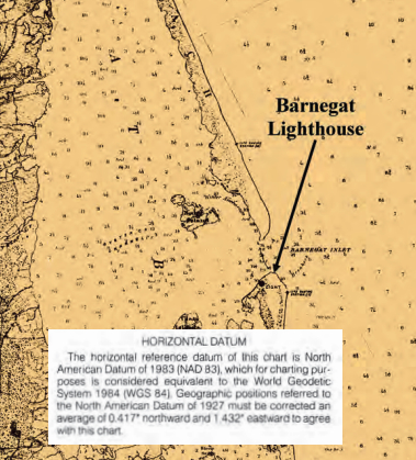
My home overlooks Barnegat Bay on the New Jersey shore. On the living room wall is an 1872 chart of the bay showing coastlines, islands, and water depths that are surprisingly similar to today’s charts. There is one big difference, however: the latitude and longitude grid on the 1872 chart is 9 miles off compared to the latitude and longitude grid on contemporary charts.
Since 1872, the mathematical concept of the Earth’s shape has changed several times, and each change has resulted in a change in the horizontal datum and a shift in the location of the latitude and longitude grid.
How the latitude and longitude grid is positioned on a chart depends on which mathematical shape, or datum, is used to describe the shape of the Earth. Many mathematical shapes are used in different places around the world. If two charts that cover the same area are drawn to different datums, the positioning of the latitude and longitude grids on those charts will likely be different. The location of the same geographic feature will be represented by two different latitudes and longitudes depending on each chart’s horizontal datum.
The position of the ellipsoid/geoid-derived latitude and longitude grid is irrelevant as long as your GPS receiver is set for the same mathematical ellipsoid/geoid (datum) as that on the chart.
Inside and outside the U.S.
The datum used on all current United States charts is the NAD 83 and WGS 84. This is the default datum of GPS receivers sold in the U.S. A GPS receiver is able to use about 100 datums that can be accessed through the GPS’s settings. When using a GPS receiver outside the U.S., it is of vital importance that you reset the datum on the receiver to match the datum indicated on the foreign chart you’re using. If you fail to reset the datum, your indicated position could be miles off.
You must then remember, of course, to set your GPS datum back to the default setting of NAD 83/WGS 84 when returning to U.S. waters and using U.S. Charts.
Don Launer, a Good Old Boat contributing editor, built his two-masted schooner, Delphinus, from a bare hull. He has held a USCG captain’s license for 40 years and has written five books. His 101 articles through November 2011 are available for downloading as a collection from the Good Old Boat download website, www.audioseastories.com. Look under Archive eXtractions.
Thank you to Sailrite Enterprises, Inc., for providing free access to back issues of Good Old Boat through intellectual property rights. Sailrite.com