Techno wizardry informs the sailor
Issue 109 : Jul/Aug 2016
Quantum leaps in technology have enabled us to leave the dock with a thorough knowledge of our planned destinations, the routes to sail, and the weather to expect along the way. Navigators today, for the most part, work with electronic media, so much so that chart tables on most (if not all) new sailboats can barely accommodate a laptop, let alone a full-size nautical chart.
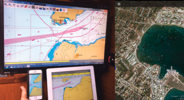
Sailors can choose from a host of navigation platforms, and I highly recommend using more than one on board, not just for the sake of redundancy but also for the wealth of unique information each platform carries. In addition to the dedicated navigation applications, another invaluable tool to include is one of the satellite imaging programs, such as Google Maps, Google Earth, and Apple Maps. On my boat, I carry three independent platforms: OpenCPN, which runs on the Windows PC; iNavX, installed on the iPad; and iSailor, on the smart phone (this also runs on the iPad).
A plethora of planning tools
When planning a cruise, I like to break it into comfortable daily distances of 20 to 30 miles. I have all my platforms open. My first step is to check the satellite image of each potential stopping place, be it a marina or an anchorage, to look for potential navigation hazards not shown on the charts. I also look for boats in the same size range as mine, as this indicates whether a particular place is likely to make a viable stopover for my boat.
A satellite image shows the berthing arrangement in any particular location: alongside, stern-to, or in individual berths. Sometimes, the water surface and the wave direction on the image will give me an indication of how protected a harbor is. I can get a feel for the popularity of an anchorage by looking at the density of the boats anchored there. A large number of boats indicates a good spot; if there are no boats at all, I’ll want to know why. I always keep in mind that the information gained from a single source could be misleading — it only shows the anchorage at the moment the image was taken. Using another source of information as a cross-reference helps me reach a more informed decision about including a location in my route.
Photos taken by boaters and others can be viewed on Google Earth. These are another valuable aid, as they help create a feel for what a place looks like and what to expect on arrival. In addition to ground contours, depths, and buoyage information, electronic charts are able to display many additional layers of data, including the locations of fuel stations, supermarkets, repair services, chandleries, and much more. Because this information is not always accurate or up to date, it’s always best to cross-reference information from at least two sources.
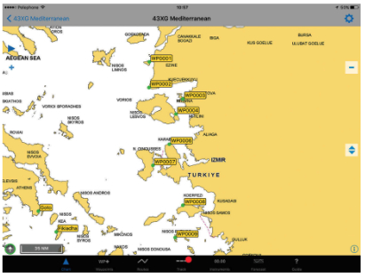
Once I have identified all the places I will stop along the route, I like to assign each one a waypoint. I number the waypoints starting backward from the final destination to the first stopover. That way, I know from looking at them how many days I have left to reach the final destination.
One more thing that must be done before leaving the dock is to get the weather forecast. Ugrib, WindGURU, and PassageWeather are just three of the many weather forecasting programs and apps available. While each program has its strengths and weaknesses, weather forecasting has become so accurate today that reliable five to seven-day forecasts are easy to obtain. Again, taking full advantage of several weather-prediction sources will help assure a safe and pleasant passage.
The voyage
Under way, I monitor the boat’s progress on a PC, a fixed display in the cockpit, or at the nav station. When trading watches with crew, I find it convenient to use a tablet or smart phone while in my bunk to obtain quick updates on position, course, speed, and nearby ships (with AIS).
On final approach to a destination, I bring the smart phone up to the cockpit. Although the screen is rather small, it’s large enough to reassure me that I’m heading toward the right cove. This sort of check could be done with the tablet, but it’s much bulkier, prone to breakage, and can reach its temperature limit in the warm sun. Murphy’s Law will prevail, and this sort of failure will happen at a critical moment.
Another reason for using a smart phone is that I can mark the position right where I drop the anchor and use it to set the anchor alarm. When anchored, I never go to sleep without the anchor alarm placed right next to me. Many anchor alarm apps and programs are available. My advice is to choose one, make it work for you, and never go to sleep without setting it.
To the technology aficionados among us, all this is child’s play. Some who are new to them may find using tablets, smart phones, and apps a bit overwhelming. Rest assured, the more you use them, the easier and more fun it gets. In the end, sailing in the age of technology allows us to get from point A to point B safely and reliably.
Menachem Lev raced Flying Dutchman dinghies before becoming an officer in the Israeli navy. When the burst of the dot-com bubble prompted a career change, he started delivering boats around the world, and subsequently became a charter boat captain in the Caribbean. Menachem lives aboard his Grand Soleil 41, Gali, and takes great pleasure in constantly maintaining and improving her. He says a day is wasted if, at the end of it, his boat is not better than it was the day before.
Thank you to Sailrite Enterprises, Inc., for providing free access to back issues of Good Old Boat through intellectual property rights. Sailrite.com