It’s the simplest, most reliable instrument on your boat
Issue 45 : Nov/Dec 2005
There are many types of compasses that help the mariner determine direction: the electronic flux-gate compass, an electronic magnetic compass; the gyro compass, which is aligned with the earth’s axis and shows true north; and the compass displays derived from global positioning satellites, which can either show true north or magnetic north. In this discussion, we’ll limit ourselves to the non-electronic, magnetic compass — the basic navigational tool that has been in use since before 1100 A.D.
Early compasses used a magnetic needle that indicated directions over a fixed card at the bottom of the compass case, but now nearly all boat compasses use a rotating card, with two or more bar magnets fastened beneath the card. In earlier times this card was graduated in 8, 16, or 32 points, but now almost all cards are graduated from 0 to 360 degrees. Some of these cards are inscribed to be viewed from above and some have edge markings, while other cards combine both displays. The card is balanced on a pivot, frequently jeweled to reduce friction, and the whole assembly is enclosed in a dome filled with liquid to dampen any oscillations of the card due to rough seas (or cannon fire). The greater the diameter of the compass card, the better its stability and visibility.
Variation
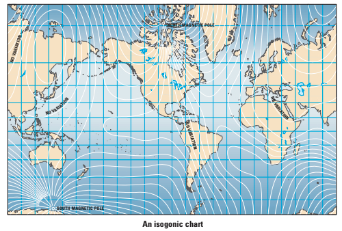
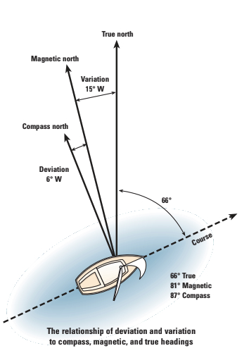
Lines of longitude on a chart are always aligned with true north. The direction to the magnetic north pole varies with location and with time. The difference between magnetic north and true north at any location is termed variation, which is expressed in degrees east or west of true north. But since the magnetic poles are continuously migrating, this variation, for any one position on the face of the earth, changes year by year. Charts of lines of equal variation, called isogonic lines, are available for local areas as well as worldwide.
Compass rose
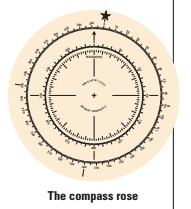
The compass rose on a chart distills all this theoretical information into a convenient, simple, and usable form. The outer ring of the rose shows bearings to the true north pole — the axis of the earth, which coincides with the lines of longitude. The next inner ring of the rose shows magnetic bearings — the actual direction to the magnetic north pole for the area covered by that particular chart. The center ring also shows the variation printed in degrees east or west, as well as the annual predicted change in that variation, along with the date that this change was predicted. This yearly predicted change in variation is only applicable for a few years from the date shown on the chart, since the movement of the magnetic north pole is erratic and unpredictable in the long term, but when using old charts, the yearly change can be extrapolated with reasonable accuracy.
Deviation
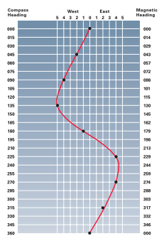
Most magnetic compasses aboard boats don’t actually point to magnetic north, however, due to other magnetic influences aboard the boat: ferrous materials, magnets, and electric currents. The difference between the true magnetic heading and the heading that the compass is showing is termed deviation. Because deviation is particular to each boat, this cannot be shown on a chart. To complicate things even more, this deviation changes with the boat’s change in direction and its angle of heel.
Thus, the difference between the true heading and the compass reading is the result of both variation and deviation. Since variation is fairly constant at any given location, this can easily be added or subtracted from the compass reading, but a deviation table must be created for each boat. Creating this table is done by swinging the compass — that is, by turning the boat through 360 degrees and adjusting the small compensating magnets within the compass until the deviation errors are minimized. The resultant, uncorrectable errors are used to create the deviation table. The details of this procedure are usually outlined in the instruction sheet when buying a new compass. They can also be found in such publications as Chapman Piloting, but by using GPS instead of the traditional methods, these compensations and adjustments have become a much simpler operation.
With a deviation table for your boat in hand, then the algebraic sum of variation and deviation, applied to the compass reading, will result in the true heading.
Compass styles
The primary mounting styles for boat compasses are binnacle mount, bulkhead mount, flush mount, surface mount, and bracket mount. The type of mount is usually determined by the physical layout of the sailboat’s cockpit, as well as the skipper’s preference. In addition, there are three basic card types available. For the direct-reading card, the heading is read from the edge of the card. Flat cards are read by looking down inside the compass bowl at the forward edge of the card, and these displays usually also include lubber lines, at 45 and 90 degrees. Dual-reading cards are a combination of direct-reading and flat cards and show the heading either by looking down inside the bowl or by looking at the edge of the card.
Hand bearing
A hand bearing compass is used to measure the direction of a sighted object relative to the user. These compasses are available either as the “hockey-puck” variety, held close to the eye, or the pistol-grip type, held at arm’s length. Both types have a means of sighting that shows the bearing of the target in degrees. The hand bearing compass is not only handy for determining your location by intersecting lines of position, it is also good to have as a backup compass or for use in the ship’s dinghy.
Thank you to Sailrite Enterprises, Inc., for providing free access to back issues of Good Old Boat through intellectual property rights. Sailrite.com