GPS, the system that supports your navigational eyes in the sky
Issue 35 : Mar/Apr 2004
In October 1957, the first man-made satellite was thrust into orbit around the earth. The USSR’s tiny Sputnik had beaten the United States into space. The United States, in an effort to learn as much about Sputnik as possible, monitored the beeping signal it transmitted and was able to determine its location through the Doppler effect. This was the genesis of using man-made satellites to determine navigational information. But it wasn’t until the 1970s that the satellite navigation system, as we now know it, began to take shape.
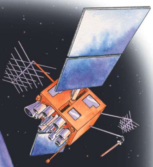
The Global Positioning System (GPS) is a satellite navigation system that was designed for, and is operated by, the U.S. military, but it is now also used by millions of civilians worldwide. The basic space segment of this system, known as the GPS Operational Constellation, consists of 24 satellites that orbit the earth twice a day. However, there are often more than 24 in space as new ones are placed in orbit to replace those that have exhausted their fuel.
There are six separate satellite orbits, usually with four satellites traveling in each orbital path. These orbits are spaced around the equator 60 degrees apart, and their orbital planes are canted about 55 degrees to the equatorial plane. Thus, a user at any point on earth has five or more satellites visible at any time (see illustration on Page 39). With access to just three satellites, a two-dimensional fix (latitude and longitude) can be determined. When in contact with four satellites, GPS receivers can compute a location in three dimensions — latitude, longitude, and altitude. This makes the GPS navigation system ideal for aircraft, as well as for boats, ground transportation, and hikers.
Atomic clocks
Each GPS satellite contains an atomic clock and, by measuring the time interval between the transmission and reception of a satellite signal, a spherical “line-of-position” is created around each satellite. The intersection of these spherical lines-of-position determines your location.
The satellites transmit in the microwave spectrum. At these frequencies, the wavelength is very short and the receiving antenna can consequently be very small. One of the problems with this frequency is that it does not easily pass through things such as house roofs, cabintops, or people. If you’re holding a hand-held GPS at waist height, the receiver has difficulty acquiring a satellite on the other side of your body.
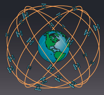
24 satellites in 6 orbital planes
4 satellites in each plane
20,200 km altitudes, 55-degree inclination
When first put into service, the GPS system was so accurate that the Department of Defense deliberately introduced an error into the civilian GPS system to prevent its use by terrorists. However this error, Selective Availability (SA), caused a potential hazard to users. If a boat were coming through a narrow inlet in a fog, the error was big enough to put it on the rocks. So the U.S. Coast Guard established low-frequency AM ground stations along the coast to take out the error introduced by the Department of Defense. This system, Differential GPS (DGPS), requires a separate antenna system and receiver that is frequently more expensive than the GPS receiver itself. Finally, in May 2000, the Selective Availability error was discontinued, and GPS users all over the world enjoyed a dramatically more accurate system.
However, there were still potential errors in the system — such as clock errors, ionospheric and tropospheric delays as the signal travels from the satellites to earth, earth reflections, satellite orbital drifts, and control errors. The DGPS ground stations could reduce most of these errors but they had limited range and were subject to noise and fading.

Same frequency band
Eventually, geostationary satellites operating in the same frequency band as the GPS satellites were put into orbit, and these new “stationary” satellites provided corrections that could be received directly on a GPS antenna without the need for a separate receiver and antenna system. This improved correction system is known as the Wide Area Augmentation System (WAAS).
As improvements continue, consumer prices for GPS receivers keep dropping, while accuracy, operational simplicity, and extra features are expanding. GPS receivers have the ability to communicate with other electronic equipment on board, such as electronic chart plotters, autopilots, VHF-FM radios, radar, and so on. The current communication protocol is known as NMEA 0183. Newer receivers that combine a GPS and chart plotter use very little battery power and provide today’s sailor with navigational capabilities undreamed of a few decades ago.
Thank you to Sailrite Enterprises, Inc., for providing free access to back issues of Good Old Boat through intellectual property rights. Sailrite.com