Accurate timing and simple geometry help your GPS sort out latitude and longitude
Issue 7 : Jul/Aug 1999
Almost as soon as radio was invented, it occurred to people that there should be a way to use it to determine the positions of ships. They started trying as early as 1912, but it was not until 1995 that they finally got it right. It was July 17, the day the U.S. Air Force formally announced that the Global Positioning System was fully operational.
GPS is the end product of a litany of lesser systems. For many decades, sailors relied on radio direction finders — which were basically table radios with rotating loop antennas and degree wheels on top. By taking bearings off shoreside radio stations, the mariner of the ’40s, ’50s, and ’60s could find out generally what part of the ocean he was in.
Under the pressure of navigating thousands of newly-built ships to England in World War II, Loran (LOng RAnge Navigation) was developed. Loran continues to work well for many people in many places. But a Loran set is likely to do a better job of returning precisely to a place it has already been than to tell you exactly where you are in unfamiliar waters. Careful use of Loran also requires using a special chart, printed with the nested curving lines of radio propagation times.
Many other ground-based systems have been built, tried, and found deficient. The era of the artificial satellite ushered in by the Russian sputnik in 1957 finally made possible the blending of a manmade system with the perfect principles of angles and distances developed from celestial navigation. It is no accident that the cloud of NAVSTAR satellites now in orbit are referred to as a constellation.
At almost any time, and in almost any location, a GPS unit will yield a position in latitude and longitude that is slightly more accurate than can be achieved with a standard U.S. Navy sextant and years of practice. People with more precise requirements and a budget to match may pay more and get more accuracy, in very special cases down to fractions of an inch.
“Wizards” is a fair term for the people who have done this for us. While the actual mechanics of GPS are beyond the scope of this article (and most people’s interests), let’s look at how GPS works for sailors, how we can use it, and what its limitations are.
Thinking globally
At its very best, with everything working perfectly and the Department of Defense not monkeying with it to hinder evildoers, GPS should be able to give a position accurate to within, roughly speaking, 20 feet.
Since the information that gives rise to that accuracy comes to us from satellites, it stands to reason that someone has to know where the satellites are with that same precision — 20 feet! That tells us that there must be a small army of orbit planners behind the curtain, as it were, keeping track of the locations of the 24 active satellites in the NAVSTAR constellation.
But since the particular 20 feet you are interested in is at the surface of the earth, not out in space, those wizards also need to know where the surface of the earth is, and with equal accuracy. And no, even sea level isn’t the same all over the world all the time. It’s been known for centuries that the earth is not spherical, but somewhat squashed at the poles. One of the first things we learned when satellites were put into orbit and when their orbital paths behaved strangely, was that the shape of the earth is a lot worse than that. It has more bulges and irregularities than an old IOR one-tonner. Not every expert agrees on exactly where they are!
That’s part of the reason why you usually find a list in the back of a GPS manual of a hundred or so “datums.” These are different people’s ideas, based on different surveys at different times and locations, of what the shape of the earth is. Such differences in shape are not trivial. In some parts of the world they could amount to a mile or more. The message for the practical boater is to find out beyond a doubt which datum your chart uses, and to make certain that your GPS (if it offers a choice of setting) is set to the same one. For most of us, in our home waters, the most common datum on our charts is WGS 84 — the World Geodetic System agreed upon by international conference in 1984.
Knowing your latitude and longitude with perfect accuracy is useless without knowing where that spot is on the planet, and only an up-to-date chart, with the proper datum, can show you that. If your GPS cannot be set to the precise datum used by the chart, there are corrections that you can obtain and apply.
One source of error is that some sources discuss and use lat/long in terms of degrees, minutes, and seconds. Others, including the U.S. Coast Guard Light List, use degrees, minutes, and decimal tenths of minutes. To make things even more confusing, some GPS receivers use one, some the other. Many allow you to select the one you want. Pay attention to which one you are using, because the difference can be large. The distance between a waypoint located at 0.5 minutes and a waypoint located at 50 seconds is about 2,000 feet. That could put you very far up on shore if you just assumed the two measurements were “about the same.”
Watching the birdies
It’s interesting and useful to know the basics of how the satellites and your receiver interact to tell you where you are.
The orbits of 24 satellites — and several spares — are set up so five to eight of them should be visible at any one time from any point on the globe. “Visible” means that the average receiver can find that many satellite signals. Physically, at 17 feet across (with their solar panels unfolded) and 11,000 miles out, the satellites are far too small to be literally visible, even with a powerful telescope.
People who work with celestial navigation have always taken pride in being on familiar terms with the stellar bodies they use. We who use GPS can do the same thing; the only difference being that our guiding bodies are manmade and invisible to the naked eye. Still, the task is easier — there are only 24 satellites versus thousands of stars, and they are arranged neatly in six specific orbits, rather than flung randomly throughout the sky. Further, each satellite has a number, and many GPS receivers tell you which one(s) it is seeing. You may want to take the trouble to develop a sense of where the satellites are, and which ones you find yourself using most frequently.
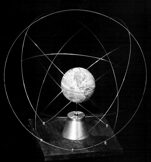
The constellation is the next step in understanding how GPS works. We know that there are 24 satellites in six orbits, which means there are four satellites in each orbit. That’s simple enough. But why the orbit is inclined at 55 degrees bears further explanation.
To more easily understand this, envision the synchronous orbits of TV relay satellites — the ones that feed that satellite dish on your roof. Those satellites are in a very simple and special orbit, and one that’s easy to visualize. This is an orbit that has an inclination of zero degrees — it lies precisely in the plane of the earth’s equator, and stays there. Since these satellites are always directly above the equator, they do not have any apparent motion north and south.
In addition to being in a special orbit plane, they are also at a special height: 19,300 nautical miles. This gives them a period of rotation around the earth of exactly 24 hours, which gives them the appearance of being stationary in the sky. The satellite and the earth rotate in unison. That keeps them from appearing to wander east or west, thus the name geostationary. TV satellites have to be in exactly this orbit, because if they were anywhere else, any higher or lower, TV watchers would go silly re-aiming their antennas every few minutes. (The system isn’t perfect, so they have to do a little of this, as it is.)
Now think of an orbit at exactly right angles to that one, a sort of meridian of longitude in the sky. It passes directly over both poles and at right angles to the equator. This is an orbit with an inclination of 90 degrees. The NAVSTAR satellites could perfectly well have been put into that kind of orbit. Among the several good reasons they weren’t is that there aren’t very many potential GPS users on the polar ice caps. The compromise was to put the NAVSTAR orbits at an inclination of 55 degrees. That keeps the densest population of satellites between the latitudes 55 degrees N and 55 degrees S — where most of the users are likely to be found.
Once you have the 55-degree orbit clearly in mind, imagine for a moment that the satellite in that orbit is crossing the equator, south to north, at precisely the 0-degree longitude — the Greenwich meridian. Now note where the additional five GPS orbits would be. Since they are equally spaced around the earth, so their south-to-north equatorial crossings are precisely 60 degrees apart, at the instant that the satellite in that first orbit is crossing the zero meridian, the planes in which the other five orbits lie are, respectively, at longitudes 60, 120, 180, 240, and 300 degrees. (OK, 240 and 300 would really be 120 degrees W and 60 degrees W, but you see the pattern.)
Another interesting detail in this matrix is how far up they are — 11,000 nautical miles is approximately three times the earth’s radius. The TV satellites are twice as far away, and have a period of rotation of 24 hours. The NAVSTAR birds, at half the distance, make a revolution around the earth in 12 hours. The result is that a given NAVSTAR satellite will pass over the same point on earth four minutes earlier each day. So it really is possible to get on a first-name basis with them.
How it works
Visualize a tripod with a camera on top. If you know how long the three legs of your tripod are, and you know exactly where the feet are, you will always know where that camera is. Change the length of any leg or move any foot and the camera will move. In simplest terms, that’s exactly how GPS works: the GPS receiver down on earth is the camera, the satellites are the feet, and the distances from the satellites to your GPS receiver are the legs. (If it helps, visualize the tripod upside down.) All the satellites have to do is tell the receiver exactly where they are and the exact time they are there — and you have your position.
But wait a minute. How does a GPS receiver know so precisely how far it is from each of the three satellites? The speed of radio waves is the same as the speed of light, which has been carefully measured. So all you have to know is how long it took the radio signal to reach you from the satellite, and you can calculate the distance. Except that an error of a thousandth of a second means an error of 186 miles (velocity of light = 186,000 miles per second). If an error of a foot were as much as we could tolerate, we would need timing accuracy to a millionth of a second — a nanosecond.
The clock on board the satellite is almost this good. The clock in your handheld GPS receiver is not, unless you paid about $10,000 for it. The clock in your average handheld receiver is about as good as the quartz watch you buy at a drugstore. How can such a crude timepiece get spectacular accuracy? Once again, the geometry of the system comes into play, and we see why the designers of the system deserve to be called wizards.
What we want to know is exactly how far your handheld receiver is from each of three satellites. Each of those satellites contains a clock that is so inconceivably accurate that the inventor of the ship’s chronometer wouldn’t even have had a word for it. It is so accurate that, for all practical purposes, the NAVSTAR satellites are transmitting identical time signals. The clock in your GPS is wrong, because it’s cheap, but at least it is just one clock. That means it will be off by the same amount of time for all three satellites it’s using.
The receiver takes the signal from one satellite, compares the time it was sent with its own time, and calculates the distance to that satellite. That distance does not go to a single point on the earth, but represents a line that could be swung in a circle, or ring of points. Then the handheld does the same thing with the other two satellites and gets two other circles on the earth. If the clock in your handheld was as perfect as the clocks in the three satellites, there would not be three circles overlapping each other, but a single point at which all three signals intersected, which would be your position.
Now, since we know the clock in your handheld has the same error for all three satellites, all it has to do is calculate what single time correction it would have to make for all three time signals to coincide at a single point. A clever high school geometry student could do it eventually; the electronic chip in your handheld can do it almost instantaneously. And voilà! — you read out your latitude and longitude on the screen.
To be a satisfied GPS user, it’s not really necessary to go much further than this. If your GPS receiver can get solid signals from three satellites, it can do the math and tell you where it is on the surface of the earth. If it can see a fourth satellite, it can go a step further and tell you what its altitude is. Boaters are for the most part unconcerned with this part of the equation, which is just as well because it’s a lot harder to explain.
Final thoughts
No doubt about it, the modern handheld GPS is a powerful and flexible tool. That said, remember what’s printed on your charts: “The prudent navigator will not rely solely on any single aid to navigation.” What if the GPS went overboard? What if there were two GPS units aboard which simultaneously got their innards turned back into sand by a lightning strike? Or what if the two GPS units simply started giving different positions — which would you trust? And never forget that the DOD owns the satellites, and can turn them off whenever it wants to. (Fortunately, this eventuality gets less likely as there come to be more large commercial users of GPS.) Any mariner who considers losing the GPS as his navigational worst-case scenario should rethink his priorities.
Just as the prudent mariner will not go far to sea without a current and accurate chart of his cruising waters, so he or she will recognize that the GPS is just the latest addition to the family of devices and techniques of the navigational repertoire. The techniques of the hand-bearing compass, the depth sounder, the speed meter, and the plotting table should continue to be part of the navigation skills of old hands, and are worthy of being learned by newcomers. There is wisdom in the words of those who say if you have a second GPS on board, it should be a Gray Plastic Sextant. If you truly venture far offshore, it could be a great comfort to know you are guided by constellations that are virtually guaranteed to be there forever.
Thank you to Sailrite Enterprises, Inc., for providing free access to back issues of Good Old Boat through intellectual property rights. Sailrite.com