How they form and how they are named
Issue 109 : Jul/Aug 2016
Sailors have been watching clouds since the first boat was launched. As aficionados know, clouds come in an infinite variety of shapes and sizes. The overall shape of a cloud and the altitude where it forms help tell the story of current and short-term weather patterns.
Making clouds
Imagine a box of air. If we analyzed its contents, we’d find a small amount of water vapor, ranging from 0.0001 to 5.0 percent by volume, depending on the location and current weather pattern. This water vapor provides the basis for cloud development — a cloud is simply a large collection of small water droplets or ice crystals (or a combination of both) that have diameters of approximately 10 microns (a human hair is about 75 microns).
If we steadily cool our box of air, the air temperature eventually reaches the dew point and the water vapor condenses into liquid form. When the temperature and dew point are the same, the air is considered saturated, a characteristic in which the relative humidity is 100 percent. Interestingly, water vapor has difficulty condensing without a little help from dust and other microscopic particles in the atmosphere. These particles, known as condensation nuclei, attract water vapor and provide a place for condensation to occur. Without a supply of condensation nuclei, clouds can’t form, even when the relative humidity exceeds 100 percent.
The cooling that promotes cloud development is typically associated with rising air. There are many exceptions, but air temperatures generally decrease as altitude increases. Even on a hot summer day, the temperature at 20,000 feet is often well below 32°F.
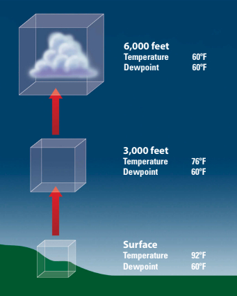
Now, let’s make a cloud. Our box of air at the surface has a temperature of 92°F and a dew point of 60°F. Since the temperature is well above the dew point, the relative humidity is less than 100 percent and no condensation or cloud droplets form. At 3,000 feet, the dew point remains unchanged, but the air temperature has fallen to 76° F. The difference between the temperature and dew point is still greater than zero, the relative humidity remains less than 100 percent, and no cloud droplets form. The cooling produced by an additional 3,000 feet in altitude does the trick and the temperature falls to the dew point. Relative humidity reaches, or slightly exceeds, 100 percent and the water vapor condenses into cloud droplets.
Naming clouds
In December 1802, Englishman Luke Howard, disenchanted with the cloud naming system then in use, designed the nomenclature that we use today. Howard was a budding scientist and envisioned a system based on Latin, similar to those used to identify plants and animals. He initially divided clouds into three broad categories, based on their overall shape.
- Cirriform clouds are thin, wispy, and relatively transparent upper-level clouds composed mainly of ice crystals.
- Cumuliform clouds are fluffy white and are often compared to cotton balls. They have distinct edges and typically show vertical development — that is, cumulus clouds tend to be taller than they are wide. This vertical development often leads to towering formations as the cloud grows upward.
- Stratiform clouds are horizontally layered featureless clouds. They can cover large areas and usually have diffuse edges.

Because categorizing clouds solely by their shape provides no insight into the altitude at which they form — a key piece of information when looking at weather patterns — a prefix indicating height was added to the naming system.
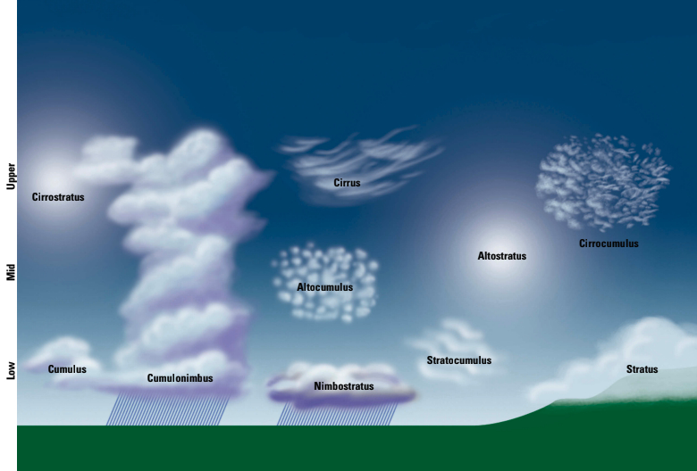
Upper-level clouds
Cirro is used to identify upper-level clouds that form above 16,500 feet. For example, cirrocumulus is a cumuliform cloud, while cirrostratus refers to an upper-level stratiform cloud. Since all cirrus clouds are upper-level clouds, there is no need to add the cirro prefix.
Halos and sundogs are the result of the refraction of sunlight off the ice crystals that comprise upper-level clouds. While upper-level clouds often precede the arrival of a low-pressure system by a day or two, they have very little influence on surface winds due to their lofty elevation.
Mid-level clouds
Mid-level clouds exist from 6,500 to 23,000 feet and are identified by the prefix alto. Altocumulus and altostratus are mid-level clouds comprised of both water droplets and ice crystals. Mid-level clouds, particularly altostratus, are often seen 6 to 12 hours ahead of the arrival of a warm front. Since mid-level clouds are closer to the surface, they may have an effect on surface winds, particularly the strength of sea (or lake) breezes and land breezes.
Low-level clouds
There is no prefix for low-level clouds such as stratus and stratocumulus. However, nimbo is added as a prefix to stratus or a suffix to cumulo, as in nimbostratus and cumulonimbus, to indicate clouds that are producing precipitation.
With the exception of cumulonimbus, low-level clouds are comprised only of water droplets. Cumulonimbus clouds are associated with thunderstorms. They are considered low-level clouds because of the altitude of their bases, but they may extend up to 35,000 feet or more. Low-level clouds, particularly cumulonimbus, may have a profound influence on the speed of surface winds.
The next time you’re drifting along wishing there was more wind, use the time to study the clouds. Maybe you’ll recognize a sign that your wind is on its way.
Mark Thornton has been sailing on the Great Lakes for more than 20 years and currently owns Osprey, a C&C 35. His company, LakeErieWX, focuses on providing marine weather education seminars, case studies, and forecasting resources to recreational boaters. His website is www.LakeErieWX.com.
Thank you to Sailrite Enterprises, Inc., for providing free access to back issues of Good Old Boat through intellectual property rights. Sailrite.com