The logic behind the old-time card markings
Issue 67: July/Aug 2009
Boxing the compass was once a very important element of the seaman’s art. Before the colorful and geometric compass rose gave way to the bland, plain-white 360-degree card, around the middle of the last century, calling off the 32 points — clockwise and counterclockwise — was something of a sailor’s mantra.
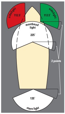
Even now, the 32 points of the compass have not entirely disappeared from use; their legacy still resides in the International Rules for the Prevention of Collision at Sea, where they are invoked to describe required arcs of visibility for navigation lights. Red and green sidelights, for example, must be visible from straight ahead to 22 1/2 degrees abaft the beam. But why that extra half degree?
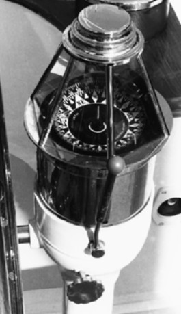
Before compass cards were marked with degrees, they were divided into 32 points. One point is therefore 11 1/4 degrees (11 ̊ 15′ or its decimal equivalent, 11.25 ̊ ). Sidelights have to be visible two points abaft the beam, that’s 22 ̊ 30′ aft of the beam. Thus, the total visible arc of each sidelight from straight ahead to two points abaft the beam is 10 points, or 112 ̊ 30′ (or, in decimal, 112.5 ̊ ). Because a masthead light scans the arc of both sidelight arcs, it is visible through 20 points, or 225 ̊.
The stern light’s arc of visibility is also based on points, this being from 2 points abaft the beam on both sides, thus scanning a total arc across the stern of 12 points, or 135 ̊. This completes the full 360 ̊ circle of light.
Easier steering
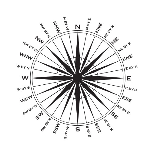
Steering by points was relatively easy because every 45-degree arc was divided into four parts, each obvious with its bold colored arrow or elongated diamond projecting from the compass card’s center. The 32 points were the total of four cardinal points indicating North, East, South, and West; four half cardinals showing NE, SE, SW, and NW; eight intermediate points, NNE, ENE, ESE, and so on, plus 16 by-points, so named because the word “by” always preceded them, as in N by E.
The points compass card almost certainly evolved from a wind rose associated with the Phoenicians who navigated, we believe, by their ability to recognize the individual characters of the eight prevailing winds of the Mediterranean Sea. These were then related to star positions according to season. Though static, a wind rose would have been an important navigational tool in those days, and it’s easy to see how a simple eight-part illustration evolved into a dynamic magnetic compass card with points multiplied four times to increase the precision to which a course could be steered.
Most commercial and recreational vessels still carry a magnetic steering compass as a vital backup tool for when the electronics crash and hand-steering becomes obligatory. This is the moment when we mourn the scarcity of the old colored compass rose whose bold points were so much easier to see in poor light than today’s bland white 360-degree card.
Toward east and west
Prior to all compasses being rationalized to 360 degrees, in some navies its four 90-degree segments were graded from 1 to 90 degrees toward east and west from north and south. In those days, bearings were clumsily stated, such as “south 10 degrees east” (today’s 170 ̊ ) or “north 50 degrees west” (today’s 310 ̊ ). For the average merchant seaman, courses were easier to follow when expressed in points of the compass, as in, “steer east-northeast” (ENE) or “steer west-southwest” (WSW).
As well as being kept alive in the arcs of navigation lights, points also remain embedded in the mariner’s spoken language, often without our realizing it. For instance, when you boast that your boat “points high” (or lament that it doesn’t “point” at all), you are comparing its performance to others using a forgotten nomenclature. An old world sailor might have said his ship sails “six points to the wind.” Today, we expect to sail at “four points to the wind,” or at an angle of 45 degrees to it.
As the magnetic compass disappears into small electronic boxes, I suspect the word “point” will stay with us, even if it does seems utterly pointless. But I, for one, would welcome a return to the colorful 32-point rose, not out of teary sentiment but rather for its card, which can be seen so easily on a dark and battery-less night.
Alan Lucas, an Australian from New South Wales, has been cruising for 40 years, primarily south of the equator. He’s authored several Australian cruising guides.
Thank you to Sailrite Enterprises, Inc., for providing free access to back issues of Good Old Boat through intellectual property rights. Sailrite.com