Electronic devices designed to save your life at sea
Issue 58 : Jan/Feb 2008
EPIRB is an acronym for emergency position-indicating radio beacon, a device designed to save your life in an emergency by alerting rescue authorities with information about you, your boat, and your location. Early EPIRBs operated on 121.5 MHz, a frequency designed for detection by boats and aircraft before satellites were available. But when satellites took over the search-and-rescue functions, this frequency was not ideal and a newer EPIRB system, operating on 406.025 MHz, became more practical and reliable and included better information about the vessels affected. (For more on this subject, see the January 2001 and July 2007 issues.)
In addition to the 406 MHz signal, the 406 MHz EPIRB transmits a homing signal on the old 121.5 MHz frequency for the purpose of guiding nearby aircraft and vessels to the beacon. While the EPIRBs using only 121.5 MHz will continue to be able to communicate with the search-and-rescue units, their satellite-location properties will be lost over time as this capability is phased out.
A Category-I EPIRB is considered the best and is the most costly. It is a 406/121.5 MHz unit that is housed on deck in a specially designed bracket. It has a hydrostatic release and is activated when it sinks in water to a certain depth. It can also be manually activated.
A Category-II EPIRB is a 406/121.5 MHz unit similar to a Category-I unit except that it can only be manually activated. It is less costly than the Category-I unit.
A personal locator beacon (PLB) is a special category of EPIRB designed to be carried by an individual. It operates on 406 MHz but can only be activated manually and, when activated, gives information about that individual as well as the location. This smaller, less expensive unit, can be carried by sailors, hikers, or anyone who will be in a remote area.
Registration
When any new or used EPIRB or PLB is purchased, it is required by law that the new owner must register it with NOAA. Also, if there is a subsequent change in registration information, this information must be updated with NOAA.
This can be done through NOAA’s website. Adobe Acrobat Reader is required to view and print these forms. Print from the Adobe Acrobat toolbar to negate any browser incompatibilities. Go to http://www.sarsat.noaa.gov and click on “Register Your Beacon.” This page gives an overview of the registration procedure. Then click on “Registration Website” for online registration. For any questions pertaining to registration, call 301-817-4515 or 999-212-7283.
NOAA only accepts registrations from the contiguous United States, Alaska, Hawaii, Puerto Rico, U.S. Virgin Islands, Northern Marianas, and American Samoa. The registration of an EPIRB or PLB can also be done through BoatUS. In addition, BoatUS rents EPIRBs to sailors who make infrequent offshore cruises and don’t want to invest in a rather expensive EPIRB transmitter.
COSPAS-SARSAT
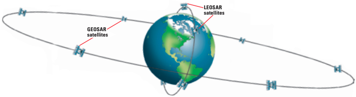
The international search-and-rescue satellite (COSPAS-SARSAT) system is composed of geostationary search-and-rescue (GEOSAR) satellites that orbit about 22,300 miles above the Earth, and low-Earth-orbit satellites (LEOSAR) that orbit 528 miles above the Earth, with an orbit every 100 minutes. The GEOSAR satellites are capable of viewing large areas of the Earth and are able to provide immediate alert and identification of an activated 406 MHz emergency beacon.
They are, however, unable to determine the location of that beacon, unless the beacon is transmitting GPS coordinates. If no GPS coordinates are associated with the emergency beacon, then the LEOSAR satellites must determine the beacon’s location using Doppler.
This Doppler-location process of the LEOSAR polar-orbiting satellites may take two or more 100-minute orbits to complete. This time could be further extended if the LEOSAR satellite is not in view of a ground station.
Thus, an EPIRB with an integral GPS transmitting the EPIRB’s location is of great value. It makes the EPIRB’s location known immediately, rather than having a delay of as much as several hours by units using Doppler-shift location of the LEOSAR satellites.
Search and rescue
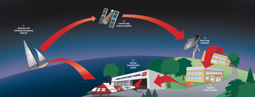
The EPIRB’s or PLB’s emergency transmitter sends a unique identification number (UIN) to the COSPAS-SARSAT satellite search-and-rescue (SAR) system. The UIN, which has previously been registered with the Coast Guard, identifies the vessel or, in the case of a PLB, the individual in trouble. This information, along with the vessel’s or person’s location, is then transmitted and received at a local user terminal (LUT), which is a satellite ground station. The information then goes to a mission control center (MCC) and from there to a rescue coordination center (RCC), from which the physical rescue operation is deployed.
One more useful tool
SART is an acronym for search-and-rescue transponder. This transponder is a battery-powered receiver and transmitter that, when activated, constantly scans the maritime radar frequencies. Upon receipt of a radar signal, the SART transmits a radar-frequency signal that will be received by the searching radar. Since the SART’s signal is much stronger than any passive reflected signal from the searching radar’s beam, it creates a unique display and greatly enhances the chances of location. If you must abandon ship, the SART should be included in your “ditch bag.”
Don Launer is a contributing editor with Good Old Boat magazine.
Thank you to Sailrite Enterprises, Inc., for providing free access to back issues of Good Old Boat through intellectual property rights. Sailrite.com