Use your own observations to refine the local forecast
Issue 66 : May/Jun 2009
A big part of guessing what the weather will do is knowing what it has just done. Reading Gord May’s excellent article, “Weather Basics,” in the November 2005 issue, prompted me to write about what we do on Callisto that helps us understand what the forecasters are predicting for our region and refine it for our locality.
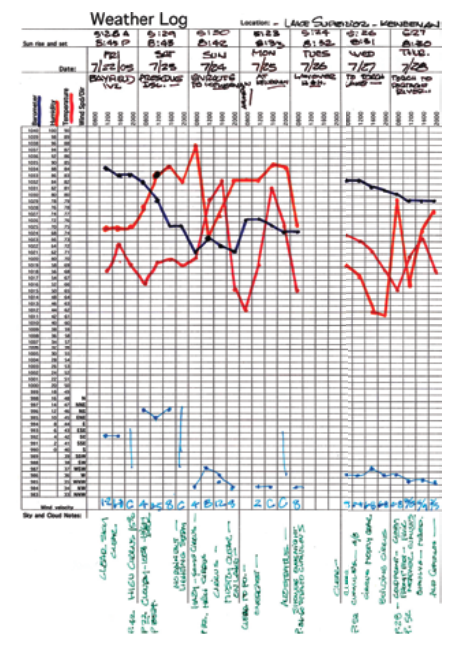
Keeping track of several elements of the weather provides clues about what may happen next. I monitor key features and record my readings on a simple spreadsheet chart. Using that information, I apply my basic weather knowledge to predict what the weather might do.
My tools for predicting the weather only cost a few dollars. Professional forecasters have hundreds of thousands of dollars’ worth of tools, radar, satellite images, computer modeling programs, and a network of weather stations with staffs to help them. Even with all that, given how many times the weather turns out differently from what the experts forecast, predicting the weather could arguably be considered as much art as science.
Forecast area
One of the big issues in weather forecasting is the region covered by the forecast. The professional looks at all the data and predicts what could happen over quite a large area, which might require a statement like: “The probability is 40 percent that it will rain today.” We, though, are only concerned with the few square miles in which we will be sailing during the forecast period. Of course, if we are going to be on a passage, we would be interested in the sea state, which is a wide-area issue and consequently affected by the larger weather picture. But what most coastal cruisers want to know is: Will it rain? How hard is the wind going to blow and from what direction? Is the weather going to get better or worse? Am I going to get a good night’s sleep in this anchorage or will I be up all night watching the sky and making sure we don’t get any wind shifts that might pull my anchor out?
Although using them brings no guarantees, a few measuring devices, a simple spreadsheet chart, and a good weather book can do much to help you predict what might happen on your little part of the planet in the next few hours.
Significant features
My chart provides a timeline in four-hour increments and is designed to track five significant weather features. You can make a similar grid with any spreadsheet program, and you’ll need four colored markers.
On my chart, I track barometric pressure, temperature, relative humidity, wind direction and velocity, and sky state. I record the temperature mostly for my own interest, since it really doesn’t help predict what might happen. I take readings every four hours, beginning at 0800 and finishing at 2000, and mark each feature in its own color so I can trace its patterns quickly and easily.
Even taking as few as four readings a day requires discipline, because I am always doing something else when it’s time to take my readings. I have a watch with four alarms that I set to give me an audible reminder at each of the reading times: 0800, 1200, 1600, and 2000.
I recently started using a Kestrel 3500, a wonderful weather instrument that will measure and store all those readings until I can either write them down or, as I often do, speak them into a voice recorder. I have found that having a small inexpensive voice recorder on board is handy for taking bearings, reviewing inventories, recording weather observations, and noting things I need to remember later.
Signs of change
Simply stated, if any one or a combination of the features I track makes a significant change in a four-hour period, a weather change is likely to occur soon. If the barometer drops 6 or more millibars, for instance, I will expect to see lower clouds and an increased probability of wet and windy weather. If the relative humidity also increases and the lower wind is at right angles to the upper wind, as indicated by the direction of travel of the upper-level clouds relative to the direction of the surface wind, I expect the weather will deteriorate. Read Gord May’s article or the book Instant Weather Forecasting, by Alan Watts, to see what combinations to look for and what the results might be.
Clouds provide important clues. Learning to distinguish the different types and the heights at which they form will help you understand what is happening in the atmosphere. Observing surface winds and upper winds can also tell you a lot about what you might expect in the next few hours. Learn about the “crossed winds rule.”
A rising or falling barometer signifies what kind of weather system is approaching or has passed by. By observing barometric pressure trends and the cloud types and wind-direction changes that accompany them, you can determine if the weather will improve or deteriorate.
With practice, you can at least forecast the likelihood of rain in your area within the next eight to 12 hours, or the approach of severe weather, and even predict with confidence that the sun will rise and set at your location.
Weather forecasting is not easy, but with a little knowledge, some practice, a few simple tools, and discipline, you can make predictions as reliable as those made by the weather gurus on the radio — and a whole lot more satisfying when they prove to be accurate.
Michael Facius is Good Old Boat’s advertising manager and sails a 1979 C&C 30, Callisto, out of Bayfield, Wisconsin, on Lake Superior. He and his wife, Patty, began sailing in 1986 with an O’Day 20.
Thank you to Sailrite Enterprises, Inc., for providing free access to back issues of Good Old Boat through intellectual property rights. Sailrite.com