Learn to make safer, faster passages
Issue 71 : Mar/Apr 2010
After spending a few days in Jacksonville, Florida, we planned to head out the St. Johns River and then turn south into the Intracoastal Waterway (ICW). We knew that once we made the turn, we’d have to decide whether to stop at one of the few available anchorages in that area or continue on a further 20 miles to the next anchorage. Our preference was to go on to the more distant anchorage because it was likely to have fewer, if any, boats in it. However, heading there carried with it the chance that nightfall and a weather front would catch us traveling through a stretch of the ICW bordered by shallow water and often heavy with traffic. Our decision hinged on whether the current would help us or hinder us.
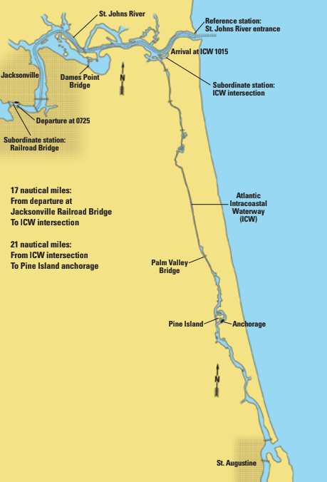
Reviewing the information for tidal currents in the area, we determined that the currents should be favorable for most of the trip. Sure enough, as we departed Jacksonville, an ebb current gave us a boost down the St. Johns River. As predicted, a flood current commenced once we reached the ICW, boosting our speed when we turned south into it. Our progress was as expected and we made it to the more distant anchorage with plenty of daylight to spare.
Tide and current data
Our source for information about tidal currents — the horizontal movement of tidal flow — was the current tables published by NOAA; in this case, the 2008 Current Tables: Atlantic Coast of North America.
NOAA also provides data on tides — the vertical movement of water. The relevant publication in this case would have been the 2008 Tide Tables: East Coast of North and South America (including Greenland). Having both publications on board is helpful and at times necessary, since the data from one publication often cannot be deduced directly from the other. For example, the times when tidal current is least generally do not coincide with either high or low tide and, in fact, can differ by up to several hours.
To time our departure from Jacksonville with a favorable current, we looked in the current tables for our reference station, the St. Johns River entrance. We determined that, on our departure date of March 28, 2008,
the time of slack before ebb would be 0234. We then looked up the time differential for the subordinate station closest to our departure location, which was the railroad bridge in downtown Jacksonville. We simply added this difference, which was 2 hours, 59 minutes, to the time at the reference station. We wanted a morning departure, so we were pleased to see that slack before ebb would occur at 0533.
To determine the time of slack before flood at our next subordinate station, the ICW intersection, we added the time difference of 27 minutes to the time of 0930 listed for our reference station. The result was 0957, and this became our target time for arriving at the intersection.
We calculated that, at 6 knots (our usual speed of 5 knots plus 1 knot of current), it would take us just under three hours to cover the 16.75 miles to the ICW intersection, so we departed at 0725. We reached the intersection at 1015 and entered the ICW on a flood current. This was a good thing, since the current tables showed that at Pablo Creek Bridge, located within the first 2.5 miles of the ICW, the current averages 5.2 knots at maximum ebb. Ultimately, we arrived at our anchorage, 20 miles farther on, at 1415.
Go with the flow
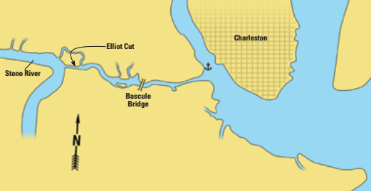
When we left Charleston, South Carolina, heading south on the ICW, we knew we would have to negotiate Elliott Cut. Tidal currents in this narrow passage can exceed 3 knots, especially if the wind, weather, and moon conspire together. We had previously passed through this cut against a stronger-than-normal current. Because we were barely able to make headway, had marginal steerage, and had no opportunity to turn around while in the cut, we preferred not to repeat the experience, particularly since tows also transit this very narrow waterway.
So, this time, prior to weighing anchor, we consulted the current tables. We established the times when the current in the cut would be at its weakest, timed our arrival accordingly, and had a stress-free passage.
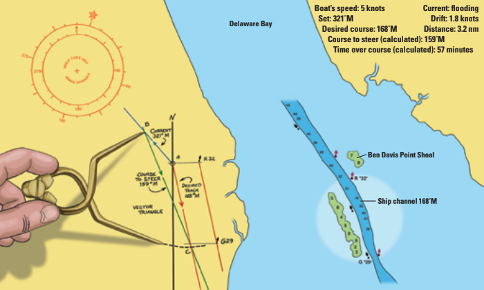
1. Start at point “A.” Use the chart’s compass rose and your parallel rule to draw your desired track line. In this case, 168 ̊M.
2. From point “A” again, draw a line at 321 ̊M to represent the set of the current.
3. Mark point “B” 1.8 nautical miles (nm) from “A” to represent the drift over a one-hour period.
4. Set your dividers to 5 nm (the distance your boat travels through the water in 1 hour at 5 knots). Place one point of the dividers on point “B” and swing them so the other point falls on your desired track. Mark this point “C.”
5. The line “BC” represents the course to steer (159 ̊M as taken from the compass rose).
6. The length of AC is the speed you will make good over the bottom. It scales as 3.35 knots.
7. The distance from R 32 to G 29 measured from the chart is 3.2 nm.
8. The time it will take you to cover that distance is 3.2 ÷ 3.35 = .955 hours. Multiply this by 60 to get minutes (.955 x 60 = 57 minutes).
Informed is fore-armed
Knowledge of a current’s set and drift can also be helpful in determining when to arrive at or depart from a dock or berth (will the current overwhelm the boat or the helmsman’s competence?), when plotting or piloting (will the boat actually go where you think it will?), and during periods of low visibility, through tricky corridors, or when traveling close to hazards (can an “incident” be avoided?).
Confused seas often develop when the current and wind oppose one another. While such conditions can make a passage merely difficult, sometimes they can become treacherous. One day, when planning for a day of sailing offshore in 15-knot winds, we consulted the current tables and determined there would be a 2- to 3-knot current in the inlet setting against the wind. We postponed making the trip by boat and instead drove out to the inlet, where we saw 4-foot seas breaking in the inlet and for a considerable distance out to sea. These conditions would not have been conducive to a pleasant sail.
In some circumstances, the danger could be even greater. For instance, when a vessel is approaching an inlet from offshore, the first inkling that there might be danger could tingle in the captain’s brain when he correlates data from the current tables with the wind conditions. A strong wind blowing contrary to a fast current creates conditions in which broaching, pitchpoling, or being knocked down are all possibilities. In such a situation, the wiser course of action might be to divert to another inlet or even stay offshore until conditions improve.
The current tables do not always provide the whole answer, as predictions are sometimes complicated by other factors. In coastal areas where the inlets are interconnected, it may be impossible to predict the set of the current for every mile. Other factors can also cause conditions to be other than predicted. These include currents entering from rivers, creeks, or other bodies of water, wind conditions, weather patterns, phases of the moon, or distance from the reference station. Any prediction made from the tables should be used with caution until shown to be without error.
Current sailing
“Current sailing” is a technique definedin The American Practical Navigator as “the process of allowing for current when predicting the track to be made good or of determining the effect of a current on the direction of motion of a vessel.”
In some settings, particularly when crossing larger bodies of water, you can plan your current sailing by using data from the current tables to plot a vector diagram on the chart.
For example, if traveling south on the Delaware Bay on a flood tide, as you near Ben Davis Point Shoal, your boat’s course would be affected by a current which could, depending on the time and day, be setting in a northwesterly direction at 1.8 knots or more. To make a safe passage, or at least an incident-free one, you would need to take into account this information, which is provided by the current tables. (See illustration on facing page.)
Today, even with electronic navigation, the need still exists to have this information on board. If darkness, fog, or other vision-limiting factors should come into play and, in addition, an electrical component were to fail, it would be important to have a source of data for set and drift, as well as the knowledge of how to use them.
Although current tables are available electronically, in our experience, the printed versions are more than adequate and provide inexpensive and readily available information at the nav station. Since they’re portable, they can easily be taken elsewhere, even to other boats. Regardless of the form in which you choose to use them, current tables are a valuable addition to the ship’s library. You will find them useful when traveling the ICW, sailing on rivers subject to tidal flow, and making coastal passages.
Jill Sechez and her husband, Rudy, have lived aboard and cruised for 13 years, beginning with a 36-foot wooden cutter they built and currently with a 34-foot sail-assisted wooden troller they designed and built. As they cruise, they enjoy writing and assisting others with their boat-repair projects.
Thank you to Sailrite Enterprises, Inc., for providing free access to back issues of Good Old Boat through intellectual property rights. Sailrite.com