Is it right for your boat?
Issue 47 : Mar/Apr 2006
Retrofitting your sailboat? Thinking about upgrading your electronics? Wondering whether you should install one of those expensive new chart-plotting radar units?
Marine radar is a big expense, carries a significant responsibility (see Rule 5, Navigation Rules of the Road), and represents another potentially troublesome electronic gadget.
But when the weather closes in, a modern radar in the hands of a competent operator is a remarkable aid to safe navigation and collision avoidance. Its ultimate value to you correlates about 100 percent with your ability to operate the radar unit, interpret radar images, and take appropriate action based on the data displayed on the radar monitor. Becoming a good radar operator makes you a better and more competent sailor.
How it works
Radar (RAdio Detection And Ranging) technology is about 65 years old. As electronics become more sophisticated, improvements and refinements continue to emerge, but one may assume that today’s radar technology — even in small systems designed for boats like yours and mine — is mature and reliable.
Marine radars for recreational vessels contain both the transmission and receiving apparatus in a single unit. The transmitter sends out a constant stream of short-pulse radio waves at about the speed of light (162,000 nautical miles per second). The rotating antenna seeks a response and determines the bearing from which the echo came. The time delay from the transmission of signals to the receipt of the bounced-back echoes is converted to distance. These data are then displayed on the radar monitor as “targets” or “marks” so the bearing and range from your present position can be visualized.
This can be an enormous aid to collision avoidance and navigation during times of restricted visibility, and even when the visibility is excellent.
Range and antenna size
When you buy a radar, do not be impressed by such specifi cations as its maximum range and power rating. On most recreational boats, the radar is used most frequently in the 2- to 6-mile range, and nearly all marine radars have more than enough power transmission to suit this need.
However, the size of the radar antenna is very important. As marine author Chuck Husick explains it, because boats use the same antenna for both transmission and receipt of the radio signals, “The radar’s transmitter energy is carefully focused, much like the light from a well-designed search-light. However, unlike a searchlight, where the desired pattern of projected light is usually circular, the energy from the radar must illuminate a relatively wide vertical swath to ensure that the target area is well covered as the boat rolls and pitches in the sea. At the same time, as the antenna rotates, a narrow horizontal beam is needed to allow objects close to one another in azimuth to be seen as separate targets and not as a single blob. Typical vertical beam angles are 25 degrees. Horizontal beam angles, which are largely determined by the length of the antenna, range from about 2.4 degrees for the smallest antennas to 0.75 degrees for antennas about 10 feet wide.”
A small antenna is better than nothing, Chuck notes, but a wider and longer antenna enhances image discrimination — separating targets close to one another — on the radar monitor display.
Mounting the antenna
Experts advise that a radar antenna should be mounted at least 4 to 5 feet above and at least 6 to 8 feet behind (or forward of) areas where anyone on board will remain in normal position while under way. Intermittent shortterm exposure to microwave energy from the radar is probably harmless, except for persons with cardiac pacemakers (who should always avoid close proximity with radar antennas). Prolonged exposure in the path of radar transmission, for anyone, should be avoided.
A conservative approach is to mount the antenna high enough so the bottom edge of the beam (12.5 degrees below horizontal) just kisses the bow or is higher than that. At the very least, people in the cockpit and people belowdecks should not be in the beam.
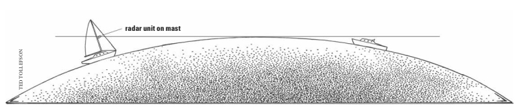
On the other hand, although radar is a line-of-sight technology, mounting the antenna more than about 20 to 25 feet above the water will not make a significant contribution to maximum range operation and can degrade the radar’s ability to show important targets close to your boat.
Radar beams are line-of-sight transmissions. The distance to the radar horizon, in miles, is about 1.22 times the square root of the height of the radar antenna in feet, so if your antenna is mounted 16 feet (square root is 4) above the waterline, the radar horizon is 4.88 nautical miles distant. If your antenna is 25 feet (square root is 5) above the waterline, the radar horizon is 6.1 nautical miles away, and if it’s 36 feet above the waterline (square root of 6), the radar horizon is 7.32 nautical miles away. Obviously, increasing the height of the antenna doesn’t gain you much horizon distance, yet the added weight higher aloft may be costly in terms of exaggerating your boat’s heeling and pitching motion. In addition, as previously mentioned, adding antenna height may defeat the radar’s ability to detect close-in targets during critical close encounters.
Use the calculation
So, in general, to learn the approximate range at which you can detect a target with your radar, use the radar horizon calculation as defined above. For targets beyond the horizon, add the square root of the antenna height on your boat to the square root of the target’s height and multiply by 1.22.
Remember that, in addition to the height of your antenna, other factors — the height and size of the target, the reflective surface of the target, and the technology of your particular radar, for example — will influence the quality of the target’s echo and image on your monitor. You may be saying, “But the product literature claims this system is rated for a range of 40 miles.” The rated range is determined by the power of the electronics to transmit a pulse to a maximum range then detect and display an echo. The rated range does not account for antenna height, radar horizon, weather, and so on.
More critical than your antenna’s height is ensuring that the antenna is mounted on a level platform, especially on a sailing vessel. As radar technicians with Raymarine explain, expanding on Chuck Husick’s observations, most systems for recreational craft have a vertical beam width of 25 degrees. This means if you could see the radar beam, you would see 12.5 degrees of beam directed downward toward the water, and 12.5 degrees directed upward, with the center of the beam aimed at the horizon.
When your boat is heeled in excess of 12.5 degrees the lower portion of the radar beam is directed above the horizon, essentially rendering the radar blind on the high side because the beam is directed above the horizon. Conversely, on the low side, all of the radar energy is directed into the water, resulting in increased sea return (clutter) on that side. From this, you can clearly see the advantage of a self-leveling or gimbaled mount for your radar antenna.
Other boats with radar reflectors in their rigging may be visible to your radar even when their hulls are not, either because they are over the horizon, or because their hulls are poor reflective surfaces. Your own radar reflector should be mounted as high as reasonably possible in order to optimize your image on another vessel’s radar.
Power requirements
Newer radar units are energy-efficient, requiring about 4 amps at 12 volts. A well-charged deep-cycle battery should be able to serve this need.
It’s nice if the power supply to the radar comes from a battery other than the one used for engine starts. That starter-motor draw may cause voltage drops below 10 volts, which will cause an operating radar to reset. A voltage drop probably will not damage the equipment, but it may cause the loss of data and may change the radar’s operating mode. You can also avoid this problem by turning your radar off during engine starts.
Radar displays
Boat size and the installed location of the radar monitor will greatly influence whether you choose a light-weight liquid-crystal display (LCD) or a larger, heavier, high-resolution cathode ray tube (CRT) display.
LCDs are more common in the cockpit because their displays are easier to see in sunlight, they are easily disconnected and stored below, and some are waterproof. CRTs show better definition when located out of direct sunlight. Therefore CRTs are at their best when mounted below. For this reason, however, a CRT radar display may be inaccessible to a short-handed crew at the very time you need it most.
Navigation
For navigation, most mariners set their radars in the “north up” mode so the radar displays correlate with nautical charts and integrated chart-plotters. The latest and most versatile radar option is the “course up” mode, which facilitates the use of radar with an integrated GPS receiver. Here the top of the screen correlates with your rhumb line course to a selected waypoint. If the boat’s heading drifts off the rhumb line, this will be displayed on the radar monitor as cross-track error (XTE), which is easily corrected. “Course up” mode may also facilitate collision avoidance.
Even without an integrated chart-plotter, a position fix is easily obtained by radar. If you and your radar can positively identify even a single prominent aid to navigation, such as the end of a breakwater, an offshore lighthouse, or a large buoy with a radar reflector or a radar beacon (Racon), that’s enough. The range and bearing of that aid will then give you a fix.
Racons, also called radar responders or radar transponder beacons, are receiver/transmitter devices installed on navigation aids such as prominent buoys and lighthouses. Upon receiving your radar pulse, a Racon transmits a unique code back to your radar set. You can match this code to that on your chart or chart-plotter, thus making a positive identification of the navigation aid. For example, in Long Island Sound there are Racons on Stratford Shoals Light (ID code _ . _ ) and Execution Rocks Light (ID code . . _). A radar range and bearing to such a mark will fix your position with reasonable accuracy.
Bear in mind that, as displayed on the system’s monitor, radar ranges are somewhat more accurate than radar bearings to a navigational aid (or another vessel). Should your radar display be superimposed over a chart-plotter, that’s even better. Whereas a GPS chart-plotter will show you what should be there, a radar may show you what actually is there.
One must be cautious because it is difficult to interpret radar echoes accurately. A small, highly reflective, target may appear bigger than a large, poorly reflective, target (on-screen intensity and size are not reliable indicators). Also, water in the air absorbs transmitted radar energy, so rain or heavy fog (as displayed on the radar scope) may obscure a navigational aid or even another vessel.
Collision avoidance
In fog, rain, and other conditions (including darkness) that restrict visibility, most experienced mariners operate their radars in the “head up” mode. This means that the top of the radar display is oriented with the bow of the boat, and targets on the display are shown relative to the boat’s heading.
“Head up” mode facilitates collision avoidance because it is easy to glance at the monitor and visualize what’s around you, including the targets’ relative position and movement. An echo that is moving toward you on a steady bearing represents a serious threat of collision and deserves your immediate attention. If avoidance maneuvers are required, remember that a significant change in your course (60 degrees or more) will be more readily apparent to the other vessel than a speed reduction.
An important point: when visibility is restricted, do not assume the other vessel has seen you or understands Navigation Rule 19, which has been interpreted to mean that there are no “stand-on” vessels (meaning that there are no “privileged” or “right of way” vessels). Every vessel must proceed at a safe speed and safe course, adapting to the prevailing circumstances, taking early action to avoid a close encounter.
Above all — with or without electronic navigation aids such as radar — remember Rule 5 of the Navigation Rules and Regulations, the sense of which is that you must at all times “ . . . maintain a proper lookout.”
Other considerations
It is useful — many say legally required — to maintain a serial plot of radar targets that represent a potential close encounter. Many modern radars can do this internally using a feature described as Automatic Radar Plotting Aid (ARPA) or Mini-ARPA. Without such a capability, the captain or radar operator should maintain manual plots of approaching targets, using a maneuvering diagram or at least a sheet of clear acetate draped over the radar display.
Practice this target plotting exercise in conditions of good visibility to develop confidence in your ability to do it when visibility is restricted.
Finally, as reliable as modern recreational radar has become, it is not fail-safe. Do not become wholly dependent upon it. Have backup systems in place: your GPS receiver should be operational, your navigator should be maintaining a DR plot on the chart and in the log, you must post a lookout, and so forth.
In today’s modern era, there’s no excuse for not knowing your position. Besides, a collision at sea can ruin your day.
Thank you to Sailrite Enterprises, Inc., for providing free access to back issues of Good Old Boat through intellectual property rights. Sailrite.com