This necessary skill comes with knowledge and practice
Issue 53 : Mar/Apr 2007
Unlike automobiles, which operate on a a solid medium, boats are always at the interface between two fluids, both of which are usually in motion. The movement of the water relative to the ground is called current. It has two components: set, the direction in which the water is moving, and drift, the speed of the current over the ground in knots. Sailors who fail to take current into account are apt to end up somewhere other than the destination they initially had in mind. The characteristics of the current you encounter differ with the kind of water you sail on.
Fresh water
Inland rivers have currents that are consistent in direction but variable in speed (constant set, variable drift). The volume of water will vary depending upon factors such as rainfall and snowmelt upstream. The speed of the current will depend on the volume of water and the shape of the riverbed. Where the river is broad, the current will be weak. Where the banks come together, the current will be strong. There are also variations from the middle to the edge of the river. Currents are usually strongest in the deepest water, normally the center of the channel, and weakest or nonexistent at the edges. There may even be a counter-current or eddy along the edge. Faster currents will be found on the outsides of bends. As rivers approach the sea, they will be affected by tides, which can stop the flow and even reverse it.
Salt water
There are consistent, known currents in the ocean — “rivers in the sea” — such as the Gulf Stream and the California Current. Even these vary from day to day and are apt to spin off temporary eddies. The ocean also has known rotary currents that change direction with the ocean tides but vary only slightly in speed (almost consistent drift, variable set).
The most complex current situations occur where the ocean meets the coast. Currents there are strongly (but not wholly) affected by the tide. Tidal streams have both variable set and variable drift. While tide and current are closely related, they are separate phenomena. The term tide refers to the change in depth, while the term current refers to the horizontal movement of the water, which may be caused by winds, tides, rivers, or massive thermal differences on the earth.
The particular terms that apply to tidal streams are:
- Flood, the movement of water inland from the ocean;
- Ebb, the reverse movement of water toward the ocean; and
- Slack, or slack water, the interval (of whatever duration, when there is no horizontal movement of water) between the end of the flood and the beginning of the ebb and vice versa.
The strength of tidal streams changes over the time each is running, building up to a maximum and then slowing down again. In addition, ebb streams are often a little stronger and last a little longer than the floods because of the influence of runoff from upstream.
Different times
While tidal currents are caused by the tide, they don’t necessarily coincide with the times of high and low water. For example, the lower York River (which fl ows into Chesapeake Bay) is restricted at Gloucester Point. This causes the currents to be as much as three hours out of sync with the tides. The current will continue fl ooding for a long time after the tide has begun to fall and the opposite is true for the ebb. In some situations, such as Hell Gate and Wood’s Hole on the East Coast and various places on the Inside Passage between Washington and Alaska, extreme narrowing of the space for the water to pass through creates a nozzle effect. This produces turbulent currents, making the passes best negotiated only for a brief period during slack water.
Wind current
Another type of current that has not been mentioned is wind current. A strong wind blowing for an extended period from the same direction (say more than 12 hours) can cause a current. This current will usually be about 2 percent of the wind strength and offset a bit to the right (in the Northern Hemisphere). This is obviously something that cannot be predicted well in advance. However, it may affect the predicted current.
There are other factors that can affect currents, so it’s good to check the current whenever you pass a fixed object, such as a buoy or daymark, in the water. The current will show up as a sort of wake on the downstream side, as if the object were being towed through still water. Observing a buoy like this can give you the set and a good estimate of the drift at that location at that time.
Similarly, if you are sailing within sight of a shoreline ahead, you can often see that you are drifting sideways by the relative movement of the land. This may allow you to compensate for cross-track error.
Sources of information
How do you find out about what currents to expect? River sailors rely on local knowledge and observation. General information on ocean currents can be found in the appropriate Coast Pilot. The government no longer publishes the tidal-current tables; they’re published by independent publishers and are available from nautical sources like the Good Old Bookshelf. There is also tidal-current information in some of the old standbys, such as Reed’s Nautical Almanac or the Eldridge Tide and Pilot Book.
You can buy tidal-current charts for certain locations. These are a set of small-scale charts of an area (such as for Long Island Sound and approaches) that use numerous arrows to show set and drift of the current for a large number of places for each hour of the tidal cycle. They not only give you a good sense of the general current pattern but also show eddies and side currents around islands, points, and so on.
Practical piloting
If the current is from dead ahead or dead astern, determining the effect of current is pretty straightforward. If the current is fair, add the speed of the current to your speed through the water. If the current is foul, subtract it from your speed through the water.
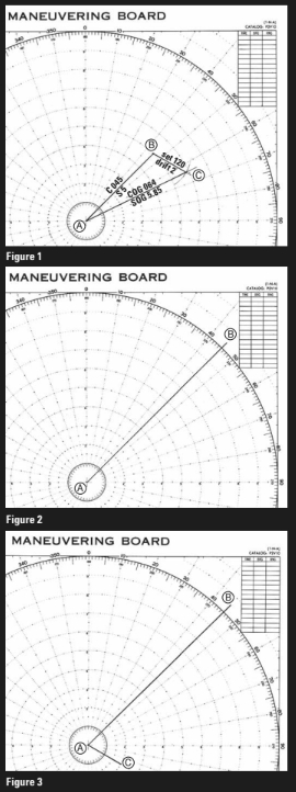
Situations where the set is neither dead ahead nor astern require a calculation of its effect. You can make this calculation graphically using a vector diagram. Vector diagrams model speed and direction, as shown in Figure 1. This diagram shows the effect of an offsetting current. Assume you are sailing from A toward B, steering a course of 045 degrees and sailing through the water at 5 knots. To plot the effect of a known current whose set is 120 degrees with a drift of 2 knots, add the current component (B-C) to the end of the course line. Adding the third side of the triangle (A-C) shows that the combined effect will be that the boat is sailing a course over the ground (COG) of 064 degrees at a speed over the ground (SOG) of 5.85 knots. Often you will not know the set and drift of the local current, but this information can be determined as shown in Figure 1. If point B is your dead reckoning (DR) position after sailing for an hour on a course of 045 degrees at a speed of 5 knots and point C is your actual position, connecting points B and C will give you your average set and drift for that hour.
In vector diagrams, such as Figure 1, speed is the length of the line. The direction it points is the course. Even if you are unfamiliar with vector diagrams, you have been using the concept whenever you navigated by dead reckoning on a nautical chart. The chart supplies direction by the compass rose, and distance (or in some cases speed) by the latitude scale.
A current calculation can be done on a chart, or it can be done using a maneuvering board, a clever device (available online from Good Old Boat) designed to calculate (using vector diagrams) all manner of nautical problems involving time, speed, and distance.
Desired course
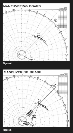
To find a heading that will, when combined with a known current, move your vessel right down the desired course of 045 in the example, draw your required track, with A as your starting point. Put point B out perhaps 10 miles, as shown in Figure 2. From A, lay off the line A-C in the direction of the tidal stream (in this case 120 degrees, as shown in Figure 3). Make the length of A-C 2 miles to represent one hour’s drift. With center C, and a radius equal to the distance traveled by the boat in one hour (in this case 5 miles), scribe an arc to cut line A-B at D, as shown in Figure 4. Direction C-D is the course to steer to maintain 045 degrees over the ground, as shown in Figure 5. The length of line A-D represents your boat speed over ground in knots.
The above calculation — complicated and theoretical as it is — is mainly useful where the current will stay constant long enough for you to navigate that way. Such situations are found mainly in the open ocean. Near land, the speed and direction of the current will be changing rapidly, so you would need to make a series of calculations, each used only for a short time. Even then, the accuracy of this method is not all that good near land. Fortunately, since Loran and GPS came into common use it has been possible to compensate for current very accurately. Simply make a waypoint along the desired course and steer the necessary heading to keep your cross-track error at or near zero. This technique will work with changing current conditions and is invaluable where rivers and bays lie along your course.
Where good visual references lie along your desired course you may be able to create ranges to follow, but this will only work part of the time.
The critical thing to remember is that where there are currents you should not simply steer toward something, be it a waypoint or a visual object. If you do that, you will follow a curved course over the ground that may take you into areas where you did not intend to go.
Currents, weak and strong, are always with us. Since the boat moves with the current, it is not obvious how it is being affected. But if you are aware of currents and plan for them, you can use them to your advantage or, at the very least, minimize any negative effects. If you do your homework before you start and remain alert to the signs as you sail, you will keep your boat sailing along the course line you intend.
Thank you to Sailrite Enterprises, Inc., for providing free access to back issues of Good Old Boat through intellectual property rights. Sailrite.com