What to expect and how to survive
Issue 47 : Mar/Apr 2006
There were all the classic signs — I was just too inexperienced, or in too much of a hurry, to pay attention to them. After a rainy night, my teenage son, Alan, and I were delivering our Bristol 22, Dona Dona, back to her home mooring near Yorktown, Virginia. We spent most of the day under a gray sky, beating into a strong southerly wind down the western shore of Chesapeake Bay. We finally made it to New Point Comfort and looked forward to falling off and making the last leg home on a screaming reach.
My heart sank as we rounded the point. Between us and home lay a squall line, a horizon-to-horizon row of evil, black thunderclouds. They were about seven or eight miles away and heading in our direction.
We immediately put about and headed downwind to the nearest shelter, Horn Harbor, about three miles away. It took less than half an hour to retrace a distance it had taken us about two hours to win. We made it into Horn Harbor and a short distance up the creek before the squall struck. Unable to anchor successfully in the strong wind and torrential rain, we were finally able to tie up at a marina to ride out the storm.
How they develop
Like most violent weather, thunderstorms feed on heat and moisture. Due to local heating or some sort of outside push, a quantity of warm air will rise like a hot-air balloon. As it does, it cools and some of the moisture condenses out as a cloud. This condensation releases heat, which adds to the balloon effect, causing the air to rise higher. Meanwhile, ground-level air moves in to replace the rising air and it, too, rises. As the process continues, a cumulus (from accumulation) cloud forms. The process may stop there, creating the typical fair-weather cumulus, or continue to build into the towering cumulonimbus cloud that will become a thunderstorm.
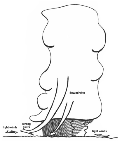
As the cumulonimbus cloud builds up into cooler regions, the moisture droplets combine into bigger drops, big enough to start falling as rain or even snow if the upper air is cold enough. By cooling some of the air and by friction, this precipitation creates downdrafts within the cloud. Once this happens, the storm is in its mature phase, marked by the presence of updrafts and downdrafts within it and by precipitation tossed up and down inside the cloud. This is when the storm is most dangerous. The cumulonimbus cloud extends above the freezing level, so some of the precipitation will freeze into hail. All that turbulent water, snow, and ice creates several million volts of static electricity, leading to the lightning and thunder that give the storm its name. A mature thunderstorm may also spin off daughter storms or even tornadoes and waterspouts.
Such a storm usually contains several cells. It can be as much as 15 miles across and will reach altitudes of 40,000 feet or more. At sea level, the effects are strong gusty winds from the downdrafts, usually heavy rain, perhaps hail, and, frequently, lightning.
While this is when the storm is at its most dangerous, it also is the beginning of the end. The strong, colder downdrafts eventually cut off the inflow of air that feeds the updrafts. Deprived of the heat and moisture to feed it, the storm slows down, spreads out, and dies. This is usually when the characteristic anvil top appears, so the presence of an anvil top usually indicates that the worst is over. A mature thunderstorm, while violent and dangerous, rarely lasts much more than an hour (though the dying storm’s cold winds may give birth to new daughter storms).
Types of storms
While some areas are more prone to thunderstorms than others and the West Coast is nearly free of storms, they can occur during the sailing season in just about any part of the country. Thunderstorms fall into two general types: the frontal storm and the airmass thunderstorm.
Thunderstorms can be associated with any frontal system, but they are most common in front of a rapidly advancing cold front. A cold front is not a wall of cold air, but more like a wedge. As this wedge moves forward, it forces the warm air ahead of it to rise. The faster the front is moving, the greater this effect will be. It is this rising warm air that develops into thunderstorms. The result is the squall line.
The rising air forms a string of thunderstorms ahead of the front. How far ahead depends on how fast the front is moving. Typically, squall lines will develop about 100 to 150 miles ahead, but the squall line may precede a very fast-moving front by up to 300 miles. In most sailing areas, squall lines will be oriented in a north-south or northeast-southwest direction. Squall lines are the most dangerous type of thunderstorm. And since the line of thunderstorms may extend for 100 miles or more, you can’t sail around them. Your best defense is usu-
ally to seek shelter immediately unless the shore presents more danger than the storm itself.
Air-mass thunderstorms, on the other hand, occur individually and locally as a result of rising thermals on a hot, humid day. They often develop and mature over the warmer land and drift out over the water. They usually don’t strike much before late afternoon, often just after sunset. You can generally watch them developing as the day goes on. Look for cumulus clouds that build up higher than their neighbors.
Dealing with them
Since squall lines are associated with fronts (usually cold fronts), your best bet is to keep track of the weather patterns over a larger area, especially to the west (since most weather systems move from west to east in North America). If there is a cold front approaching, be aware that it may be preceded by squalls. The weather forecast will be most useful in that situation. You can also watch for the usual signs, such as lowering clouds and a falling barometer. As Alan and I learned, cold fronts usually are preceded by strong southerly or southwesterly winds.
On the other hand, air-mass thunderstorms are typical on warm, humid summer days. If you’re sailing on such a day, keep an eye on the sky. Watch the cumulus clouds that are common in those conditions to see if any are growing especially tall. Unless it is very hazy, you can usually spot the thunderheads as they develop. It may also be prudent, especially if the clouds are hidden by a heavy haze, to simply get to shelter by mid-to-late afternoon. If the light “looks funny,” something is up.
Once a thunderstorm is fully developed, you can judge its distance from you by counting the seconds between when you see a lightning bolt and when you hear the associated thunder. Divide that number by five; that is the distance in miles to the storm. It is hard to determine the speed and direction of an air-mass thunderstorm unless you watch it for a while. Don’t be fooled by surface winds, which often blow toward the growing cumulonimbus. Thunderstorms are moved and steered by winds aloft, which may differ in speed and direction from the surface winds. Typically, thunderstorms move at a speed of about 20 knots (though this can vary), so you aren’t going to be able to outrun them.
The safest thing you can do when you spot (or suspect) a thunderstorm in your vicinity is to head for shelter. Wind gusts out of a thunderstorm, especially the first cold ones, are commonly 40 knots but can go as high as 80 knots. Combining that with heavy rain, possible hail, and lightning bolts dropping all around you makes a thundersquall something you don’t want to mess with if you can avoid it. Your best defense is to be snugged down in a sheltered area.
If you are caught out and can’t reach shelter in time, you still have some options. Reef down and put on your foul-weather gear before the storm hits. Remember, the first wind out of the storm will be the strongest; 40 to 60 knots is not unusual.
Strongest winds
Exactly how you deal with a storm will depend on your boat and your sailing area. You may decide to run off under jib and furled main. While you will usually be sailing in the strongest winds, running with them lessens the apparent wind on the boat but may keep you in the storm longer. If you don’t have running room to leeward, or if you appear to be near the edge of the storm, you may decide to reach across the storm in the hope of getting out of it. Given a choice, there may be some advantage to reaching across an oncoming storm on port tack. While you can meet hail in any part of a thunderstorm, it is more likely (and heavier) in the right rear quadrant of the storm.
If the water is shallow enough you may opt to anchor and ride it out. If you can’t avoid a squall line, you may be able to maneuver between two storms, though don’t expect an easy ride. Whatever you do, anyone not needed to handle the boat should be sent below. If there is lightning, everyone should stay clear of metal objects, such as masts and rigging.
Keep in mind that thunderstorms, though violent, are relatively short-lived. (This is especially true of the summer-afternoon, air-mass variety.) The excitement is of limited duration, and the weather afterward can be quite different.
After spending a rainy night, Alan and I set out again the next day to complete our delivery. It turned out to be one of our best sails of the season.
Thank you to Sailrite Enterprises, Inc., for providing free access to back issues of Good Old Boat through intellectual property rights. Sailrite.com