Issue 142: Jan/Feb 2022
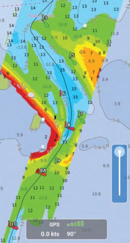
I spend a lot of time navigating shoal waters, and my dedicated (and expensive) chart plotter only gets fresh information about such places when I install an updated SD card, yet another expense. That’s just one reason I’m so pleased with the Aqua Map app; with the Aqua Master subscription, the U.S. Army Corps of Engineer (USACE) overlay provides up-to-date, easy-to-read depth data. The overlay uses colors to show the safest passage through trouble areas and the spots to avoid. I have found surveys that are less than two months old, really fresh data. And, Aqua Map alerts you when its frequent updates are ready to download.
 Like most chart plotter apps, Aqua Map lets you plan (measure distances and set waypoints) and navigate your route. You can activate and download data from your ActiveCaptain or Waterway Guide account, so that real-time information is displayed.
Enable the satellite overlay, controlled with an on-screen slider, to layer satellite views over your chart. Use two fingers to swipe up for Aqua Map’s “bird’s-eye view” for a different perspective on what is approaching. Another two-finger swipe down returns you to overhead view.
The anchor alarm will help you rest easy, and tide and current data help plan your timing. Aqua Map’s record feature is a great way to document your trip. Just press the REC button in the top left-hand corner as you get underway, and Aqua Map will record your track. Click on the track to stop recording and read the available track information, which includes total distance, total time, average speed, and maximum speed. You can add all the detail you want in the track description, and it’s easy to save tracks and then to back them up through your GEC account (the app’s account manager tool) when connected to WiFi. This means you can load your tracks any time to review a passage.
Aqua Map Master also includes WiFi to connect to your NMEA devices and the ability to display AIS data. I didn’t test the WiFi and AIS features, but I did try out Route Explorer (iOS only, but promised for Android soon), which also comes with the Aqua Map Master subscription. Route Explorer constantly looks ahead and alerts you when you are approaching features such as a bridge, marine hazard, or a marina—good information to know at a glance.
You can download Aqua Map for Android and iOS (Apple) for free, then purchase charts you desire from within the app. I have the United States forever, a $24.99 one-time cost. Aqua Map Master costs another $10, bringing the total cost for an extremely powerful chart plotter to $34.99. Through the GEC, you can share Aqua Map Master, as well as charts, routes, pictures, etc., across up to five devices.
Overall, I find Aqua Map more intuitive and easier to use than my expensive, dedicated chart plotter, with more readily updated information and at far less cost. For more information, globalaquamaps.com.
Thank you to Sailrite Enterprises, Inc., for providing free access to back issues of Good Old Boat through intellectual property rights. Sailrite.com